Trail Walking Les Belleville - Tour de Creve Tete  - Photo
 zazie
zazie

User

© OpenStreetMap contributors
Length
Length
18.1 km
Max alt
Max alt
1980 m
Uphill gradient
Uphill gradient
1166 m
Km-Effort
Km-Effort  
34 km
Min alt
Min alt
1347 m
Downhill gradient
Downhill gradient
1166 m
Boucle
Boucle
Yes
Creation date :
2019-07-29 07:46:24.45
Updated on :
2019-07-31 15:43:38.477

(1 Reviews)

Walking
Walking
4h49
Difficulty : Medium

Scan this QR Code to open this trail in the SityTrail application

FREE GPS app for hiking

Logo SityTrail SityTrail

IGN / Geographical institutes

Download SityTrail from the App Store Download SityTrail from Google Play

Logo SityTrail SityTrail World

The world is yours!

Download SityTrail from the App Store Download SityTrail from Google Play Download SityTrail on Huawei AppGallery

About

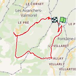
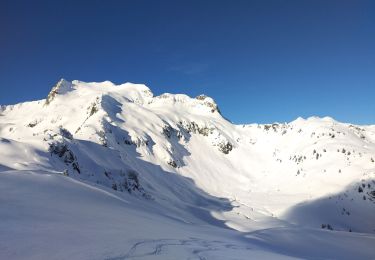
Trail Walking of 18.1 km to be discovered at Auvergne-Rhône-Alpes, Savoy, Les Belleville. This trail is proposed by zazie.

Description

Départ effectué depuis la montée mécanique de Pierrafort. Vue sur le massif du Mont-Blanc après le village Le Novallay et le plan Lachat. Après le Plan Lachat, bien rester sur le chemin forestier.

Elevation profile

Photos

21 photos in total. Please click on a photo to see them all in the gallery.

Positioning

Country:
France
Region :
Auvergne-Rhône-Alpes
Department/Province :
Savoy
Municipality :
Les Belleville
Location:
Saint-Jean-de-Belleville
Start:(UTM)
303871 ; 5037875 (32T) N.

Comments

Please log in to post a review or rate the element


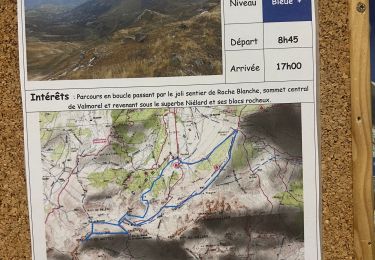
Erreur dans la saisie de la catégorie de difficultés, i' s'agit plutôt d'une randonnée moyenne. Envoi de la fiche trop rapide. Désolé


Trails nearby

Trail Walking Hautecour - Le sentier artistique de Hautecour - Photo
Walking
gilsep

Walking

Easy
(1)
Hautecour, Auvergne-Rhône-Alpes, Savoy, France
4.2 km | 7.2 km-effort
1h 32min
Yes
Trail Mountain bike Les Allues - Col de la Lune depuis Le Villard - Photo
Mountain bike
tracegps

Mountain bike

Difficult
(1)
Les Allues, Auvergne-Rhône-Alpes, Savoy, France
10.2 km | 18.1 km-effort
4h 0min
Yes
Trail Touring skiing La Léchère - tricotage vers Les Teurs. - Photo
Touring skiing
nadd73

Touring skiing

Easy
La Léchère, Auvergne-Rhône-Alpes, Savoy, France
13.1 km | 28 km-effort
4h 2min
Yes
Trail Touring skiing La Léchère - Les marmottes noires  - Photo
Touring skiing
nadd73

Touring skiing

Medium
La Léchère, Auvergne-Rhône-Alpes, Savoy, France
13.2 km | 28 km-effort
4h 50min
Yes
Trail Touring skiing La Léchère - le. chalet de Colomban  - Photo
Touring skiing
nadd73

Touring skiing

Easy
La Léchère, Auvergne-Rhône-Alpes, Savoy, France
10.1 km | 22 km-effort
2h 0min
No
Trail Walking Les Avanchers-Valmorel - La pointe du Mottet - Photo
Walking
dautriche

Walking

Medium
Les Avanchers-Valmorel, Auvergne-Rhône-Alpes, Savoy, France
10.9 km | 21 km-effort
4h 59min
Yes
Trail Walking Les Avanchers-Valmorel - Crêve Tête - Valmorel - Photo
Walking
dautriche

Walking

Easy
Les Avanchers-Valmorel, Auvergne-Rhône-Alpes, Savoy, France
11.6 km | 20 km-effort
4h 34min
No
Trail On foot La Léchère - 15352435-Randonnée 1 VTF: balade découverte nature - Photo
On foot
Christiancordin

On foot

Easy
La Léchère, Auvergne-Rhône-Alpes, Savoy, France
5 km | 7.2 km-effort
1h 37min
Yes
Trail On foot La Léchère - 15352545-Randonnée 6: Valmorel  - Photo
On foot
Christiancordin

On foot

Medium
La Léchère, Auvergne-Rhône-Alpes, Savoy, France
15.3 km | 23 km-effort
5h 9min
Yes


Close
My subscriptions